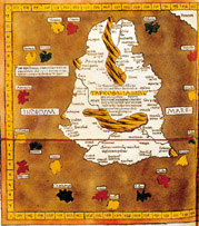
Sri Lankan Muslims
In Search of Taprobane: the Western discovery and mapping of Ceylon
by Ananda Abeydeera
 Western cartographic interest in Taprobane, later
Ceylon now Sri Lanka, is of hallowed antiquity. In
Western cartographic interest in Taprobane, later
Ceylon now Sri Lanka, is of hallowed antiquity. In
pre-Christian times, it was Onesicritus, companion
of Alexander the Great's campaigns in northwestern India, who gave that name to
an island in the Southern Sea.
Determining its size, shape, and exact
position was a vexed question from the earliest ages of classical geography and
there has long been speculation among the ancient Greeks and the Romans as to
whether Taprobane was a second world or whether it was a very great island.
Strabo, the geographer and historian who oriented it wrongly in the direction
of Ethiopia gave its length as over 5000 stades and Eratosthenes estimated the
length of the island as equal to 8000 stades.
 Repeating a similar misconception of his time the
anonymous Greek sailor from the Roman Egypt stated in the Periplus Maris
Erythraei That Taprobane extended from the east to the west and that it was
large enough almost to reach the coast of Africa. Pomponius Mela was uncertain
whether he should consider Taprobane a large island or the commencement of
another world. Hipparchus saw it as a new hemisphere and the Elder Pliny, the
celebrated Roman encyclopedist, observed that it was held to be another world
and that it was discovered to be an island only in Alexander's time. Ptolemy
depicted it as an Indian ocean island of nearly continental size giving it 15
degrees breadth and located it athwart the equator in the final regional map of
his Geography.
Repeating a similar misconception of his time the
anonymous Greek sailor from the Roman Egypt stated in the Periplus Maris
Erythraei That Taprobane extended from the east to the west and that it was
large enough almost to reach the coast of Africa. Pomponius Mela was uncertain
whether he should consider Taprobane a large island or the commencement of
another world. Hipparchus saw it as a new hemisphere and the Elder Pliny, the
celebrated Roman encyclopedist, observed that it was held to be another world
and that it was discovered to be an island only in Alexander's time. Ptolemy
depicted it as an Indian ocean island of nearly continental size giving it 15
degrees breadth and located it athwart the equator in the final regional map of
his Geography.
Ptolemy's Geography fell into oblivion in
the West, only to be revived after the fall of the Byzantine empire in the
fifteenth century when it became available to European scholars through a
number of editions. In this way, the ancient name "Taprobane" also
was revived, but it now had to compete with another, newer name,
"Saylam", one of the several names Sri Lanka knew during its long
history. An island called Saylam was known to the West as early as the
thirteenth century through the travel account of Marco Polo. Apparently
European cosmographers and travellers did not understand that
"Seylam" or "Seylan" of their time was merely another name
for island Ptolemy called "Taprobane" twelve centuries earlier.
 The great esteem in which Ptolemy was held on matters
of geography and cartography was such that travellers and map makers, believed
in its existence, were now looking for an obsolete Taprobane, a name that was
long lost.
The great esteem in which Ptolemy was held on matters
of geography and cartography was such that travellers and map makers, believed
in its existence, were now looking for an obsolete Taprobane, a name that was
long lost.
The name Taprobane had been applied to
Sumatra from the fifteenth century onwards, after a misunderstanding by the
Italian traveller Nicolo di Conti. Conti was the first European traveller who
distinguished Ceylon from Taprobane and identified the latter as Sumatra, which
it will be noted, athwart the equator. Subsequent geographers, historians,
cosmographers and thinkers alike became engaged in a controversy over its
proper identification. Considerable confusion began to exist as to whether
Ceylon or Sumatra was the island of Taprobane described by Eratosthenes,
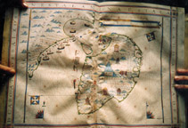
Strabo, Pliny, Ptolemy, Cosmas, Indicopleustes and depicted in the Hereford,
Ebstrof, "Catalan Atlas' mappaemundi and on Fra Mauro's planisphere and
Martin Behaim's globe. The maps such as "Cantino", "Caverio"
and "Contarini" have misled the contemporary viewers who in their
turn transmitted this confusion either through implicitly casual discussions or
even deliberately explicit instructions to mapmakers who in their turn propagated
it just as naively and with the same degree of intelligence as their informants
through the documents they were producing for their immediate users.
Groping in the hazy conceptions of his
geography to make sense of his discoveries, Christopher Columbus, finding
himself on Hispaniola, thought that he had already reached Taprobane and made
an offering thereof to Ferdinand and Isabella thinking they were worthy of
possessing an island of such vast magnitude. Castilian prelate and overzealous
friar Jimenezd de Cisneros disparaged Columbus's pretensions that he had been
to Taprobane but asserted that he himself would embark upon a voyage in search
of the "true Taprobana" if their most Christian majesties would
favour him with their permission and provide him with a formidable fleet.
In the course of the Renaissance in
Portugal, at the height of their geographical and political expansion, there
took place a flurry of serious discussions on the Taprobane question. All the
chroniclers, cosmographers (including the author of the "Cantino" and
"Caverio" maps) and King Dom Manuel himself who sponsored the
expeditions of discoveries seemed to think that they were obliged to express
their opinion in one way or another on this controversial issue. The two
letters that King D. Manuel addressed to the Emperor Maximilian and Castillian
kings served the purpose of bringing into fuller knowledge of the latest news
that concerned Taprobane, subsequent to the return voyage of Vasco de Gama. The
third letter that D. Manuel addressed to the Cardinal protector, announces that
his power extended as far as "Taprobana considered a long time ago as a
another world".
Taprobane stirred the minds of people in
every country and filled them with wonder. Scholars of all nations and
persuasions entered the fray: in Portugal, Joao de Barros, Diogo do Couto, Luis
de Camoes, Faria e Sousa, Garcia da Orta, and Castanheda; in Italy humanists
such as Porcacchi, Bordone Ramusio, Fra Castoro, Gastaldi, the travellers and
adventurers Nicolo di Conti and Ludovico di Varthema and the famed discoverers
Caboto, Amerigo and Juan Vespucci; Tommaso Campanella located his utopian
"City of the Sun" on Taprobane to reflect his dream of converting all
mankind to Catholism; in Germany and France, such reputed cosmographers as
Sebastian Munster, Andre Thevet, and Francois Belleforest; and among prominent
mapmakers, Waldseemuller, Laurent Fries, Mercator, Ortelius, and Hondius; in
Spain the chief cosmographer of Philipe II Alonso de Santa Cruz and humanist
Las Casas,
Cervantes made Don Quixote and his faithful
squire, Sancho Panza two of the greatest characters in European fiction to
encounter the emperor and lord of the great island Taprobana.
The peculiar geographical vicissitudes of
Taprobane drew the attention of leading figures from western history, Ramusio,
Gossellin, Kant, and Cassini who concerned with the dilemma, attempted to
resolve the question of Taprobane's identification with countries ranging from
Sumatra to Madagascar: Venetian geographer, historian and humanist Ramusio
relying on an account of an anonymous Portuguese and based on geographical and
astronomical data sought to reconcile the location and dimensions of Sumatra
with the position and size of the island that Iambulus the Greek merchant
claimed to have discovered. The aim of his argument thereby was to determine
that this island was precisely the Taprobane of the classical authors.
To justify the greatly exaggerated size that
Ptolemy attributed to Ceylon, the French geographer, Gosseinn, assumed that the
geographers of Alexandria erroneously considered the entire landmass of the
Deccan from the Bay of Cambay downwards as separated from the Indian
subcontinent and hence depicted it as forming part of the island of Taprobane.
Immanuel Kant, the foremost thinker of the Enlightenment, lecturing on physical
geography, on the other hand, rejected the strange hypothesis of Gossellin that
Taprobane in fact was the virtually non-existent Dekkan Peninsula in Ptolemy's
map of India, ventured to maintain that it was nothing other than Madagascar
situated far apart from both the Dekkan and Sumatra. Prominent astronomer and
geodesist Giovanni Dominique Cassini took a totally divergent view and sought
in the Maldives archipelago sufficient proof to salvage Ptolemy's Taprobane inundated
by tempestuous tidal effects of the sea, and the remaining atolls alone
attesting to where it had been before.
R. V. Tooley thought Ptolemy's inflated
'Taprobane' may have been distended with place names from Sumatra as well as
from Ceylon. Norman J. W. Thrower spoke about Ptolemy's truncated India with an
exaggerated Taprobane. Crone wrote that Ptolemy perhaps confused the greatly
overestimated size of Taprobana with the peninsular form of the Indian
sub-continent.
Seeking a possible explanation for causes
which might have generated this deformity, J. Schwatzberg drew attention to he
troublesomeness of the usage of the term dvipa in the Indian cosmographic texts
which is variously rendered as "island", "Island continent"
or simply "continent" and assumed that the southern region of Deccan
might have been taken by Ptolemy as a great southern island without any
recognition of its separateness from ancient Lanka. For this assumption
Schwatzberg based his argument on a faulty translation he made himself from
French to English, of a commentary by Gossellin on Ptolemy's India. Susan Gole
thought that Taprobana was in fact the peninsula of South India, mistakenly
divided from the mainland.
Forty and fifty years ago, Pierre Paris and
Jean Filliozat of the Ecole francaise de I'Extreme-Orient became the partisans
of a polemic respectively rejecting and maintaining the identification of
Ceylon with Taprobane. Although recent decades have given us important
historical contributions supported by archaeological, philological, and
numismatic evidence to elucidate sufficiently this vexing question, the recent
exchange of views on the Internet discussion list MAPHIST gives the impression
that the issue is still unresolved. On top of all that, very recently. S. Arasaratnam
and Alain Bartleet seem to misunderstand the interpretations of historians
thereby complicating further an issue already heavily confusion-laden.
Besides its intrinsic interest to students
of South Asia, the Taprobane story, with its broiling controversies and
conflicting interpretations will shed important light on the processes of
discovery and on the transmission of geographical knowledge in classical times,
in the Middle Ages, and in the era of the great discoveries. Taprobane, like El
Dorado, Ultima Thule and Atlantis, was a touchstone for the geographical
imagination.
A talk titled The Western Discovery and
Mapping of Taprobane (Sri Lanka) will be delivered at the Sri Lanka Foundation,
Institute, Lecture Hall 3, Torrington Square on Friday 18th February 2000 at 5
pm by its writer of this article who is a researcher, and formerly visiting
lecturer at the School of Oriental Languages and at the Ecol des Hants Etudes
on Sciences Socially, Paris.